


Two decades ago ecologist Ilka C. Feller heard about a plant advancing at an unprecedented rate into a coastal restoration site near Merritt Island on Florida’s Atlantic coast, midway between Miami and Georgia’s southern border. The plant was a mangrove, a tree that thrives in salt water and grows in stands along the ocean’s edge. The tree’s roots form a tangle that extends several feet out of the water, and its thin, tawny trunk and branches reach up into a dense canopy of waxy, jadelike leaves. Stands can stretch for miles, forming a biologically diverse forest that builds land by trapping sediment and protects coastlines from erosion, waves and storm surges. Mangroves have long defended coasts against hurricanes, cyclones and tsunamis, which researchers have shown are more deadly along shores without the tangled trees. Mangroves capture vast amounts of carbon, too.
There are more than 70 species of mangrove, adapted to hot habitats with soil low in oxygen. They filter out almost all the salt that enters their roots and thrive in places where few other plants can. They grow around the world but only at tropical and subtropical latitudes, in places that don’t have periodic freezes, which can prevent the plants from becoming established. Mangroves were not supposed to be at Merritt Island, but when Feller showed up in 2002 and started looking around, there they were.
Feller then drove to Tomoka State Park, about 70 miles farther north along the Atlantic coast. A park ranger told Feller there were no mangroves there, but she decided to look anyway. Sure enough, a few hundred yards past the ranger station she found small mangrove shrubs dotting the salt marsh. The following morning she drove another 40 miles north toward St. Augustine, Fla., which is only 60 miles south of the Georgia line, and she found a few isolated mangroves there, too.
On supporting science journalism
If you’re enjoying this article, consider supporting our award-winning journalism by subscribing. By purchasing a subscription you are helping to ensure the future of impactful stories about the discoveries and ideas shaping our world today.
Over the next 20 years Feller and her colleagues documented the poleward migration of mangroves in North America—and, by proxy, the shifting border of the subtropics. Since 1980 the world has lost more than 35 percent of its mangroves because of development, pollution and extreme weather. In parts of southern Florida, more than 50 percent have been destroyed. Yet in northern Florida, on the East Coast, mangroves have doubled in area. In Australia, the trees are migrating east to west rather than poleward. In Brazil, mangroves are creeping inland as rising seas push salt water deeper into the interior. And in South Africa, mangroves are migrating south, extending the subtropical boundary just as they are in Florida. It’s unclear how far the mangroves will travel. But the migration offers a picture of the future as temperatures climb, weather patterns shift and sea levels rise. And recent discoveries have reshaped almost everything scientists thought about their movements.
Feller began her career in 1975 as a scientific illustrator at the Smithsonian Institution. Her interest in mangroves began after she met a sponge curator who learned she was an experienced scuba diver. The curator asked Feller to develop an underwater drawing technique. Feller agreed, and soon she was depicting the coral reef off Belize on sheets of drafting film fastened to a plexiglass drawing board. She later joined that curator to research mangroves in Panama, where she swam up channels through remote mangrove forests with her drawing system. She drew the roots and the juvenile fish swimming among them, as well as seagrass and corals. When she wasn’t drawing, she collected insects. “I felt I could be there by myself all day and be totally happy,” Feller says. “It just turned out to be a place that I fit.”
For two decades Smithsonian ecologist Ilka C. Feller has been tracking mangroves’ relentless migration northward from central Florida.
Engrossed by the plants, Feller left Central America and went back to school for a Ph.D. in ecology. In 1997, just after turning 50, she returned to the Smithsonian as an ecologist. “I couldn’t believe I got a job,” she says. In the past two decades Feller, now 77, has established research sites throughout the Caribbean, Belize, Panama, Ecuador, Australia and New Zealand, as well as Florida and the Gulf of Mexico’s rim, studying the role of nutrients in mangrove stands, the species bound to the plants and the trees’ migration. She is an author on more than 700 papers, including studies involving fieldwork in Saudi Arabia, Brazil and Indonesia, and she is widely regarded as a pioneer of experimental mangrove ecology. Some call Feller the godmother of mangrove ecology. Others call her “the mangrove queen.” (Her friends call her Candy.)
In the early 2000s Feller started recording mangroves she found north of St. Augustine, in the space between two different types of habitat, an ecosystem transition known as an ecotone. This region is where she could find clues to how the coastline would change as freezes became less frequent and hurricanes became more frequent. Storm currents can carry mangrove seeds far away, helping to broaden their range. But storms can harm the trees, too; in 2019 high winds, storm surge and prolonged floods from Hurricane Dorian destroyed more than half the mangrove forests of Grand Bahama.
More mangrove habitat could be a promising defense against sea-level rise. The trees also sequester more carbon than any other plant, both above and below the ground, another counter to climate change. But they could also overtake salt marshes, with consequences. The marshes—vast, open areas of green, grassy wetlands bisected by serpentine creeks, flooded daily by tides—line parts of coasts in the U.S. and many other countries. They support vegetation, host imperiled bird species and filter water, helping coastal ecosystems flourish. About 75 percent of U.S. salt marshes are in the Southeast, precisely where mangroves are appearing. Although mangroves build land faster than salt marshes do—in some cases, four times as fast—they’re much more vulnerable to cold temperatures. One severe freeze could eviscerate a forest, leaving the soft land vulnerable to erosion. “You could have that wetland go to water real quick,” says William “Ches” Vervaeke, an ecologist with the National Park Service.
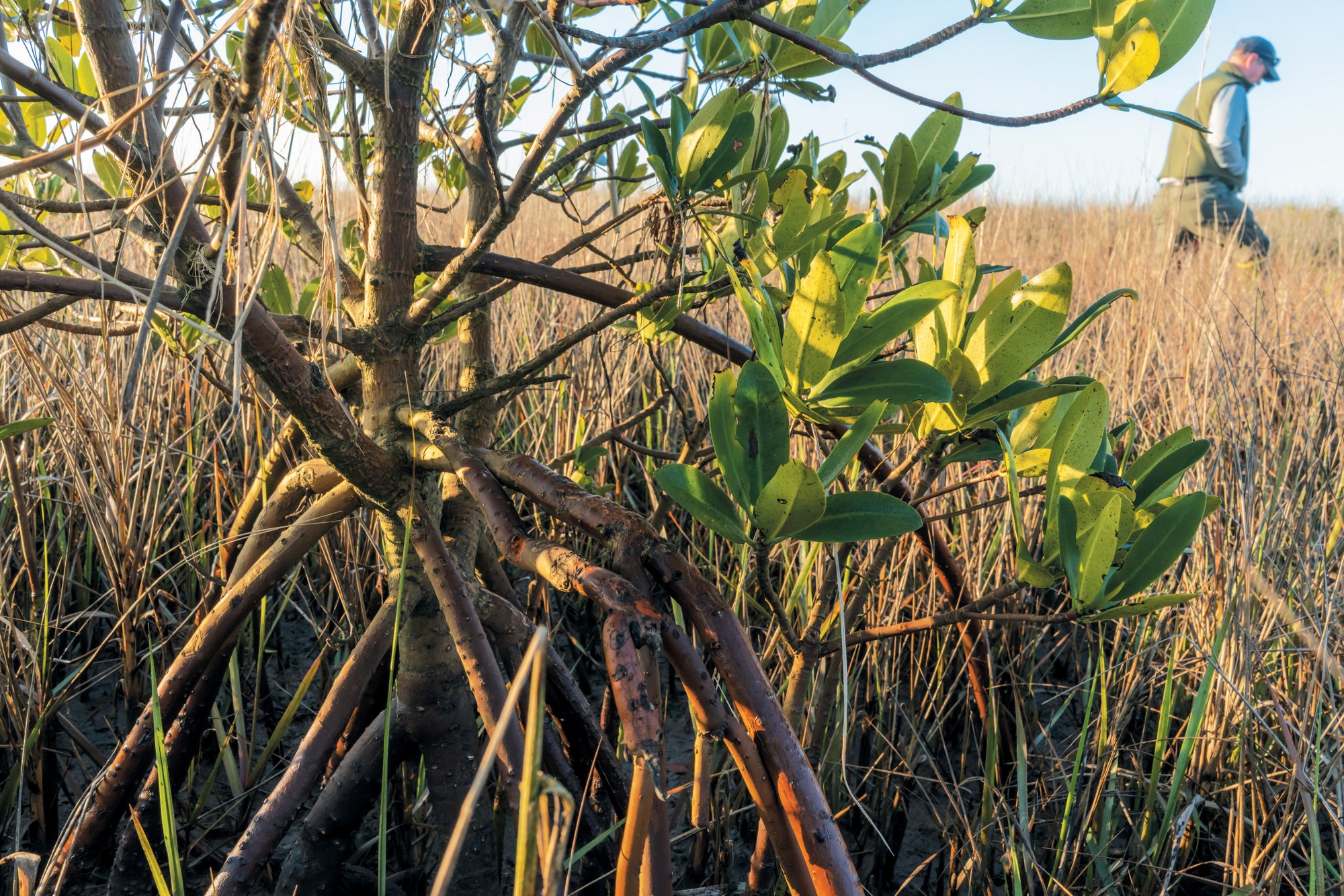
In Florida, there are three species of mangrove: red, black and white. The red mangroves grow closest to the water, the black a bit farther in from the water’s edge, and the white in the higher elevations along the coast. Strangely, the three species are not related, but over millions of years they evolved in the same harsh environment. They resemble one another in form and location and in how they reproduce.

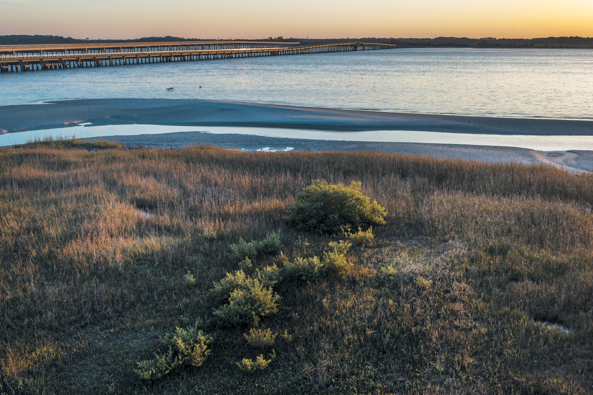
Mangroves are establishing forests along open salt marshes such as this one in Florida’s Bulow Creek, 100 miles south of the Georgia line.
By the time summer rains begin in Florida, red mangroves put out delicate chartreuse flowers, which will eventually bear fruit. Then a long, pen-shaped propagule with a lithe curve appears. If you pry open a mature propagule with your fingernail, you will find a seedling ready to fall out. The propagules drop off the plant—often into the water, where they may be carried a few inches or hundreds of miles. White mangroves produce tinier flowers, densely organized fruit and a propagule the size of a green bean. The black mangrove’s propagule is slightly larger and asymmetrical.
As spring turned to summer in 2016, Feller’s search took her up Florida’s east coast until she finally headed into Nassau County, the state’s northeasternmost county, where the Nassau River meets the sea. One afternoon she and a postdoctoral researcher were driving on a long, low bridge over the river toward Amelia Island, just shy of the Georgia line, when an emerald shrub in the distance caught their eye. They hit the brakes, parked and ran under the bridge toward the marsh. On the other side of a tidal creek, a black mangrove stood like a sentry. At 30.3 degrees north, the specimen was situated one third of the way between the equator and the North Pole, 60 miles north of its previously recorded range—by far the northernmost mangrove in the U.S. Later, they called it “Candy’s Mangrove.”
Soon after, Feller’s peers started to find other black mangroves in that same area. Then, in 2021, Vervaeke was running a skiff along the Fort George River a few miles south of Amelia Island. Breaks of cedar trees line the bluffs along the river where dense stands of oaks are littered with resurrection ferns and orchids. The place “is kind of a hidden gem,” he says. That day Vervaeke looked out from the small boat and spotted a set of bright green leaves amid the dull spartina grass. He realized he’d found a red mangrove, the northernmost in America, a companion to Candy’s black mangrove. “I almost literally jumped out of the boat to go and look at that thing,” he says.
Vervaeke expected to find black mangroves because they can tolerate lower temperatures to some extent, but a red mangrove was unprecedented. The species defied logic, proliferating on various banks of various rivers. “The intriguing part that captures my imagination,” says ecologist Scott F. Jones, an assistant professor at the University of North Florida, “is that we still don’t understand and therefore can’t predict where exactly mangroves are going to show up.”
Early one morning last December, Vervaeke led me through a tiny clump of cedar trees and sabal palms and into a marsh just north of Jacksonville, Fla., where the Fort George River meets the Atlantic in a plateau of sand banks flanking spartina grass and narrow channels. About 100 yards ahead of us Jones and Feller were examining leaves of mangrove shrubs. They were looking for signs of a type of crab and an insect, called a psyllid, that are typically found on trees farther south. As the trees creep north, so should the species tied to them.
A red mangrove, named for the color of its roots, stakes a claim on Fort George Island, only 20 miles from the Georgia border. Climate change is reducing freeze risk at increasingly higher latitudes.
At one point, my head was buried inside a small shrub, following Feller’s fingers as she aged the tree by counting sections of stem between nodes on its branches, which corresponded to seasons of growth (summer, long section; winter, short section.) Over time researchers noticed that active hurricane seasons were often followed by mild winters, which helped young plants take root after the storms spread propagules north.
Later that day Jones, Vervaeke, Feller and I headed north to the rim of Amelia Island to visit Candy’s Mangrove. A light rain fell as we walked out toward the site. When we reached the ribbon of water separating the beach from the strand of marsh, it was too deep to cross without swimming. We opted for a warm lunch instead, waiting for the tide to drop. As we turned back toward the car, a bald eagle flew along a break of slash pines before landing in a nest. I wondered what the migration of this plant into the marsh would mean for birds and other animals, especially if mangroves replace salt marsh. The contrast between the two habitats is stark.
With more mangrove habitat, “there is a probable win for birds in many ways,” Andrew Farnsworth, a visiting scientist at the Cornell University Lab of Ornithology, later told me. Mangroves in southern Florida are essential habitat for migratory species, and more than 30 percent of Europe’s avian population spends winters in mangrove forests in West Africa. “Of course,” Farnsworth said, “this will be at the cost of some salt marsh specialists” such as eastern black rails, whimbrels and salt marsh sparrows.
Any real-world transformation probably wouldn’t be so simple. “I think these places are going to be a matrix of both salt marshes and mangroves,” says Samantha Chapman, a biology professor at Villanova University. But in some areas, she says, it might be a “total transition.” She thinks that, over time, there will be push and pull, creating additional habitat for some species while inevitably forcing others to look elsewhere. Many Florida game fish, for example, especially snook and tarpon, use mangrove estuaries as nurseries. In the past decade, however, researchers have found those juvenile snook and tarpon in marshes where there are no mangroves, including spots as far north as South Carolina. This shift shows that the fish can survive in varied habitats, and if other forces such as rising sea temperatures push them farther north, they may be able to adapt.
In other places, changes are more peculiar. Along the northern edge of the Amazon Delta, mangroves have been expanding inland as the rising sea inundates the low-lying coast. In some cases, that water follows navigational channels carved by residents and even the trails trod by wild water buffalo, forging paths along which salt water can creep inland and propagules can drift. The migration is “quite striking,” says Carlos David Santos, an ecologist and assistant professor at the NOVA School of Science and Technology in Portugal, who has been monitoring 500 miles of uninterrupted mangrove forest in Brazil. Some formerly freshwater lakes there are now composed entirely of salt water, displacing fish such as arapaima that are favored by local communities. What disturbs Santos and others is how quickly changes are taking place: as habitat for shorebirds and macro invertebrates disappears along the coast, critical wetlands farther inland are rapidly becoming tight-knit mangrove forests.
Along the mouth of the Leichhardt River in Australia, increased precipitation and increased sediment accumulation have caused mangroves to expand out into the Gulf of Carpentaria; just a few miles west, mangroves are trending inland owing to prolonged periods of wetland flooding. In New Zealand, researchers have documented a rapid seaward migration of mangroves around Auckland. Over time people there altered rivers to suit agriculture, and increased sediment, coupled with higher levels of nitrogen and phosphorus from field runoff, has driven the mangroves’ migration.
After tracking the movement of mangroves up Florida’s coastline, Feller started to search through historical texts, looking for any clues about the trees’ earlier whereabouts. That’s when she found an anecdote that reshaped everything researchers knew about their range in the U.S.
In 1867 naturalist John Muir set out on foot for a journey across the South. His account of the trek was published posthumously in a 1916 book, A Thousand-Mile Walk to the Gulf. At one point, Muir crossed the St. Marys River from Georgia into Florida. As his boat drifted toward Fernandina Beach, a town on the river just south of the state line, he saw “clumps of mangrove and forests of moss-dressed, strange trees appearing low in the distance.” This would have been roughly 15 miles north of Candy’s Mangrove. If the description was accurate, the current consensus that mangroves had never grown so far north was wrong. Feller eventually found another mention from 1837 and a record from 1821. She ended up tracing the trail back to 1788, when French botanist and explorer André Michaux found mangroves south of Candy’s.

Researchers Ches Vervaeke (left) and Scott Jones (right) document a black mangrove beside the St. Marys River, which forms part of the border between Florida and Georgia.
Feller then sketched a time line of freezes based on citrus growers’ records, along with a map of hurricane paths. (After Hurricane Irma in 2017, Feller found mangrove propagules along the beach on Jekyll Island, 20 miles north of the Georgia line. She even found intact roots and branches.) She sent all these notes to Kyle Cavanaugh, an assistant professor at the University of California, Los Angeles, Institute of the Environment and Sustainability. Cavanaugh collected climate data for the Florida coast from 1950 to 2017. And Wilfrid Rodriguez, a researcher at the Smithsonian, pulled together aerial images of the Matanzas Inlet just south of St. Augustine going back to 1942. Together the records, data and imagery revealed a curious expansion and contraction of mangroves.
The team concluded, in a 2019 paper, that mangroves were not simply migrating north. Instead there was sophisticated, long-term movement of plants both northward and southward—“regime shifts” dictated by weather. Freezes pushed the mangrove boundary south. Often the habitat was replaced by salt marsh. But during mild winters and active hurricane seasons, mangrove forests slowly migrated north again.
In northeastern Florida, fluid transformations between mangroves and salt marsh occurred at least six times between the late 1700s and 2017, Feller says. But the researchers say that with annual temperatures rising relentlessly, freezes decreasing and hurricanes becoming more powerful, the northward migration of mangroves in recent years may become permanent. Soon enough, mangroves will spill into Georgia and then inevitably into South Carolina. The trees aren’t simply marching north; they are taking leaps when the elements allow and falling back only slightly, if at all, when cool air reaches south.
In January 2024 Vervaeke and Jones invited me to join them as they looked for the next biological borderland of the subtropics. They dropped a skiff into the Nassau River, a few miles north of Candy’s Mangrove, and headed north as the tide rose, carving through the backcountry until we reached the Intracoastal Waterway, which runs north to south. The first stretch of our search didn’t yield anything. Four miles farther north, though, we all shouted, “There!” The unmistakable hue of a red mangrove sat beside a stand of cedar trees. Vervaeke and Jones were ecstatic; this was farther north than any other mangrove they had seen, and it was a red, too. Minutes later we found yet another red mangrove—the new northernmost tree. Using a GPS transmitter, a computer tablet and an orange notebook, Vervaeke and Jones recorded the coordinates, elevation and plant measurements.
As mangroves push poleward, they could transform salt marshes into a matrix of trees and grasses—or take over completely.
We continued north toward Fernandina Beach. Less than five minutes later, Jones pointed: “There.” Another mangrove, this time a black one. The day continued like that as we found tree after tree farther and farther north—in the Amelia River, along Lanceford Creek and deep in the network of marshes that make up Tiger Island near Georgia’s southern border. By the time we reached the state line, where the St. Marys River runs into the Atlantic, we had recorded 19 successive “northernmost” mangroves, most of which were red.
With the wind dropping, Vervaeke couldn’t resist making an unplanned run across the river into Georgia. The marsh there feels endless, the live oaks along the shoreline ancient. The vast span of the St. Marys River pours out toward Cumberland Island, between the lime-green edges of the marsh. As we pressed against another shoreline, one plant poked up above the grass. Jones was skeptical, but Vervaeke smiled. Could it really be a mangrove, the first in Georgia? As Vervaeke set the boat onto an oyster bar, Jones ran over toward the plant. He reached the top of the bank and looked back, beaming. Vervaeke just laughed and gathered his equipment. “I’ll be damned,” he said.
On the run home, Vervaeke, who had tattooed the prior northernmost mangrove’s coordinates on his arm, thought about making an appointment to update it. Back in the truck, they called Feller to tell her they’d found 21 new northernmost mangroves. Two of them were in Georgia. “No way!” the mangrove queen shouted. “I’ll be there soon.”


